


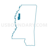
Rome Voting District, Sunflower County, Mississippi
About
Outline

Summary
| Unique Area Identifier | 606713 |
| Name | Rome Voting District |
| County | Sunflower County |
| State | Mississippi |
| Area (square miles) | 75.48 |
| Land Area (square miles) | 75.39 |
| Water Area (square miles) | 0.09 |
| % of Land Area | 99.88 |
| % of Water Area | 0.12 |
| Latitude of the Internal Point | 33.94098750 |
| Longtitude of the Internal Point | -90.55534970 |
Maps


Graphs
Select a template below for downloading or customizing gragh for Rome Voting District, Sunflower County, Mississippi


Neighbors
Neighoring Voting District (by Name) Neighboring Voting District on the Map
- Cagle Crossing Voting District, Coahoma County, MS
- Drew Voting District, Sunflower County, MS
- Glendora Voting District, Tallahatchie County, MS
- Mound Bayou Voting District, Bolivar County, MS
- Roundaway Voting District, Coahoma County, MS
- Shelby Voting District, Bolivar County, MS
- Sumner Beat 5 Voting District, Tallahatchie County, MS
Top 10 Neighboring County Subdivision (by Population) Neighboring County Subdivision on the Map
- District 5, Sunflower County, MS (8,430)
- District 3, Bolivar County, MS (5,952)
- District 5, Tallahatchie County, MS (5,211)
- District 5, Coahoma County, MS (4,902)
- District 4, Coahoma County, MS (4,633)
- District 4, Tallahatchie County, MS (1,858)
Top 10 Neighboring Unified School District (by Population) Neighboring Unified School District on the Map
- Coahoma County School District, MS (8,189)
- Drew School District, MS (7,422)
- West Tallahatchie School, MS (7,096)
- North Bolivar School District, MS (3,264)
- Mound Bayou Public School, MS (2,542)
Top 10 Neighboring State Legislative District Lower Chamber (by Population) Neighboring State Legislative District Lower Chamber on the Map
- State House District 30, MS (19,921)
- State House District 29, MS (18,559)
- State House District 26, MS (18,014)
Top 10 Neighboring State Legislative District Upper Chamber (by Population) Neighboring State Legislative District Upper Chamber on the Map
- State Senate District 11, MS (48,319)
- State Senate District 13, MS (46,404)
- State Senate District 24, MS (45,527)
- State Senate District 12, MS (43,572)
Top 10 Neighboring 111th Congressional District (by Population) Neighboring 111th Congressional District on the Map
Top 10 Neighboring Census Tract (by Population) Neighboring Census Tract on the Map
- Census Tract 9501, Sunflower County, MS (7,472)
- Census Tract 9503, Tallahatchie County, MS (5,459)
- Census Tract 9501, Bolivar County, MS (3,805)
- Census Tract 9503, Coahoma County, MS (3,267)
- Census Tract 9503, Bolivar County, MS (3,168)
- Census Tract 9504, Tallahatchie County, MS (2,786)
Top 10 Neighboring 5-Digit ZIP Code Tabulation Area (by Population) Neighboring 5-Digit ZIP Code Tabulation Area on the Map
- 38614, MS (20,418)
- 38963, MS (4,015)
- 38738, MS (3,998)
- 38737, MS (2,932)
- 38774, MS (2,522)
- 38762, MS (2,294)
- 38966, MS (1,174)
- 38768, MS (182)